Hello everyone. This is the first post in about a good five months or so. As mentioned in my previous post, course work from the Spring semester and research duties at the University of Colorado had taken priority. However, there are many posts coming on and you can refer to that to see what will possibly be coming in the future. For now, that is a different story, so let’s get on with the topic at hand.
According to forecasters at the National Weather Service (NWS) office in Miami, the official start of the 2013-14 dry season began on 10 October. This was determined by the first “cold” front passage of the new season which helped to drop dew points into the upper 50s to low 60s over most of south Florida. The low dew point values made the humidity over much of the area bearable despite the air temperatures being in the still-warm mid 80s. Low temperatures below 70 degrees were observed in many areas for the first time since early May. But the biggest change in the air is the ending of the daily thunderstorm pattern and a return to a drier and more stable environment.
In essence, the dry season is more specifically defined by the following:
- Dewpoints below 65F degrees for more than 3 straight days.
- Nightly air temperatures near 70F degrees or below.
- Reduced precipitation days with several straight days of sunshine.
So now we can put the last 6 months of daily rainfall behind us and focus on the sunshine and cooler days ahead in the upcoming dry season. What can we expect this season? It may be too soon to tell, but we can use various models to get a better understanding of what may possibly lie ahead. I’ll do my best to try and explain the tricky stuff as efficiently as possible.
CURRENT OCEANIC CONDITIONS
Before getting to the forecasts, we must understand the origin of the conditions at hand. A large indicator of a phase presence is the standing of the sea surface temperatures (SST). The main reason we analyze this is because the SST values are one critical factor in determining the state of either an El Niño or La Niña. So you may be asking yourself, what is the difference between the two? What is so significant about each other? Below is a quick summary of this for both conditions.
In an El Niño phase, conditions are as follows:
- SST values above +0.5C degrees from the norm.
- Air pressure over the island of Tahiti and most of the Pacific Ocean.
- Rising warm air over Peru with rainfall over the Peruvian deserts.
- Trade winds in the southern Pacific weaken.
And these are the implications of El Niño’s presence:
- Warmer and drier over the northern half of the USA and Canada.
- Cooler and stormier over the southern half of the USA and northern Mexico.
- Less active hurricane season in the Atlantic; More active hurricane season in the Pacific.
In a La Niña phase, the conditions and implications are practically the opposite of El Niño. South Florida has endured 2 La Niñas in the past 3 dry seasons (2011 & 2012). Between these two systems is the ENSO-Neutral phase, which lacks properties of both La Niña and El Niño. In an ENSO-Neutral phase, conditions across the Pacific remain relatively stable with little to no deviation in SSTs.

Figure 1. Average sea surface temperature (SST) anomalies as of 2 October 2013.
Figure 1 above shows the deviation from the normal sea surface temperature values on 2 October. It is noted that there is slight cooling along the equatorial Pacific Ocean with slight warming across the Western Atlantic and Gulf of Mexico. The spread is generally about -0.5C to +0.5C degrees from the norm.

Figure 2. Computerized Niño values.
An expansion of global SSTs and their departure from the norm can be better shown in Figure 2 (above). This figure describes a time progression of SST value departures from the normal for various coordinates on Earth. It follows this order (numbers in degrees, letters in the cardinal direction):
- Niño 4: 5N-5S, 150W-160E
- Niño 3.4: 5N-5S, 170W-120W
- Niño 3: 5N-5S, 150W-90W
- Niño 1+2: 0-10S, 90W-80W
These are all indicators of fluctuating SSTs in the Pacific and western Atlantic waters, which could lead to a better understanding of the conditions at hand. Using the guidance described above, we notice that there are deviations of +0.1C, -0.4C, -0.2C, and -0.4C degrees, respectively. The average of these four values is above the -0.5C degree deviation threshold. Therefore, we could be looking at a potentially ENSO-Neutral dry season over south Florida.
CLIMATE FORECAST FOR THE DRY SEASON
Because of the reduced confidence of wintertime forecasting, not much can be said about accuracy in the forecasts at this point in time. However, the folks at the Climatological Prediction Center (CPC) have drawn up a forecast for the next several months (up to 12 months actually, but we will stick with the next six months or so).
First half- November 2013 to January 2014
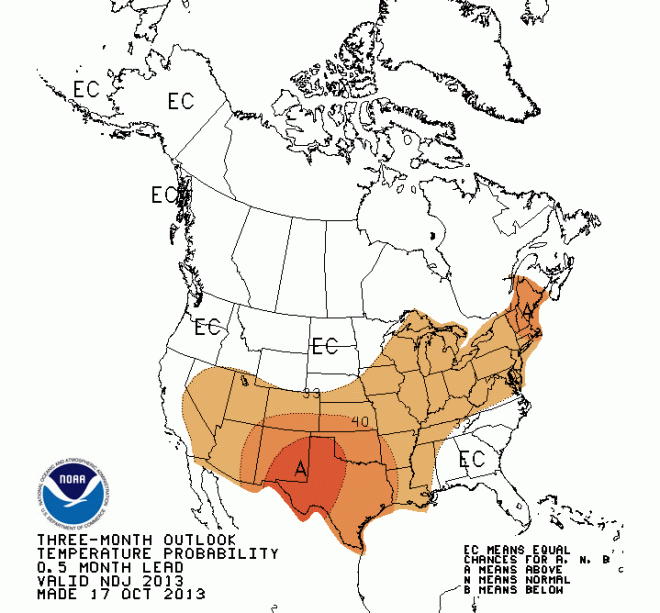
Figure 3a- Above/Below normal temperature forecasts for Nov-Dec-Jan

Figure 3b- Above/Below normal precipitation forecasts for Nov-Dec-Jan
Based on the current SST values across the Pacific Ocean, ENSO-Neutral to very weak La Niña conditions will be felt here in south Florida, highlighted by the slightly higher (33%) chance of below normal precipitation over south and central Florida, and a moderate (40%) chance of below normal precipitation over northern Florida. Away from Florida, it is worth noting that this forecast also exists for Texas & Georgia and parts of New Mexico, the Carolinas and Arizona (see Figure 3b). As far as temperatures are concerned, most of the southern portion of the country will have a slightly greater (33%) chance of seeing above average temperatures this winter, but south Florida has an equal chance (<33%) of seeing above and below average temperatures. Note that the conditions could be impacted with any change in the El Niño/La Niña index.
Second half- February to April 2014

Figure 4a- Same as figure 3a, except for Feb-Mar-Apr.
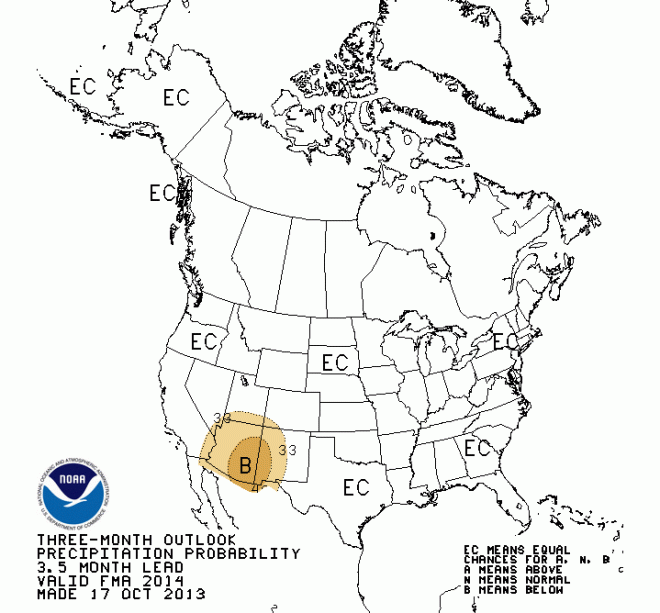
Figure 4b- Same as figure 3b, except for Feb-Mar-Apr
For the second half of the dry season, it appears that ENSO-Neutral conditions are more prevalent over the US, namely south Florida. There is a widespread area of an equal chance of above or below normal precipitation for the area throughout these three months (Figure 4b). This is the same for the temperature forecasts, remaining consistent with the 1st half of the dry season.
WHAT IS EXPECTED THIS DRY SEASON LOCALLY?
So having answered all of that, the answer to the question is this: South Florida is expected to have a drier start to the dry season than normal, followed by a return to more of a typical pattern of dry/wet conditions over the second half of the dry season. Here is the breakdown of individual events to look to in each half:
1st half of the dry season (November-January)
- Increasing chances of stronger cold fronts as the winter gets closer and enters.
December and January are the two “coldest” months of the year for south Florida, with average temperatures below 70 degrees area wide (averaging maximum and minimum temperatures) The first freezes for south Florida (if any) occur in late December and the chance can persist into late January. The most recent significant freeze threat occurred in December of 2010, where most of south Florida fell below the critical freezing 32F degree (0C) mark for 2-3 consecutive nights. South Florida’s risk of these significant fronts is slight relative to central and northern Florida, but it only takes one to do significant damage.
- Cold fronts bring less instability as the time to winter approaches. But, the wind speed and direction still changes dramatically once the front passes.
A cold front that arrives in October typically has more instability than a cold front arriving in mid-December. Simply put, the surrounding air ahead of a cold front is more stable near the winter months as opposed to early Fall. Therefore, expect only light to moderate periods of rain ahead of a cold front closer to December and January. However, changes in the wind flow patterns are the same. A southerly wind ahead of the front will quickly switch over to a northwesterly wind and pick up in speed once the front clears the area. Temperatures will drop quickly once this occurs. Florida cold fronts are known to bring in windy conditions after all.
2nd half- February to April:
- Wildfire threat increases dramatically.
As we clear the “coldest” months of the year for south Florida and temperatures begin to warm back up, the air above us will still remain very dry. As temperatures begin their return to the 80F degree mark, humidity levels may still remain comfortable (below 40% at times). Perhaps, too comfortable for large trees and fire to mix up easily. Wildfires are more prevalent between March and April, when the contrast between temperature and dewpoint is high. This “dry heat” is fuel for any wildfire to pop up in wooded areas. This would be time to exercise common sense and caution while around large trees and properties with trees.
- Return to severe weather threat.
Instability in the air begins to increase as more heat is reintroduced during the spring months. Cold fronts do occasionally pass through south Florida, but they do not go quietly. Lightning, strong winds, heavy rains, and even the threat of tornadoes returns to the south Florida scene in the early to mid spring months. Florida’s peak in severe weather is usually April, so this would be the time to start paying close attention to the radars ahead of impending cold fronts.
———–
So that should cover it all for the first post back. Contact me on my twitter feed (@BrianWxFLA) if you have any questions regarding my posts. If there is any significant update to this issued by the CPC or NOAA, I will update and relay the information to you.
Onward and upward,
Brian
IMAGE CITATIONS:
National Center for Environmental Protection. ENSO Cycle: Recent Evolution, Current Status and Predictions. College Park, October 28, 2013.
NOAA Climate Prediction Center. Three Month Outlooks Official Forecasts. College Park, October 15, 2013.