Special update on cold front thunderstorms

Hello everyone. The first cold front of the season is approaching fast, but not before a squall line of thunderstorms comes barreling through south Florida tonight and into early tomorrow morning.


RADAR OVERVIEW

Figure 1. Radar observation from KEYW in Key West, FL at 8:44 PM.

Figure 1. Radar observation from KEYW in Key West, FL at 8:44 PM.


The latest series of radar passes shows a long line of strong to severe thunderstorms a good 50 miles offshore from the west coast of south Florida. The current forward speed of the overall system is roughly to the ENE at 25 mph, losing some of its pace from earlier. The combination of this forward speed and current position situates the line about two hours from Collier and Glades counties and about 3-4 hours from impacting the east coast areas such as Miami-Dade, Broward, and Palm Beach counties. Offshore buoys have measured rainfall rates as high as two inches per hour in some of these cells along with frequent lightning and high winds. At the current speed, below are the expected arrival times for the storms:

Collier county:

Coastal/Metro: 10:15-10:30 PM

Inland:  10:45-11:00 PM

Miami-Dade:

Everglades: 11:45 PM- 12:00 AM

Metro: 12:15-12:30 AM

Coastal: 12:45 AM-1:00 AM

Broward:

Inland:   12:00 AM- 12:15 AM

Metro:    12:15 AM- 12:30 AM

Coastal:  12:45 AM-1:00 AM

Palm Beach:

Inland:   12:00 AM- 12:15 AM

Metro:    12:15 AM- 12:30 AM

Coastal:  12:45 AM-1:00 AM


Also notice how there is a second line behind the main line. That also has the potential for organization and will affect the areas about an hour or two after the initial line passes. As far the cold front is concerned, the front will pass through tomorrow morning. Expect temperatures to stay steady during the morning and early afternoon hours and begin to fall as the afternoon and evening progresses. Winds are expected to shift to the northwest at night and that will move the cooler air towards us. Stay tuned for updates on Twitter.


Weather Discussion for 14 Nov- 20 Nov

Hello everyone. I am aware that I’ve had to postpone several posts to later dates but as I said, the schedule was subject to changes as time progressed. However, please stay with me as I am doing my best to keep up with or as close to the schedule as possible. Anyways, onto the good stuff, here’s the forecast discussion for 14 Nov- 20 Nov


CURRENT CONDITIONS

Figure 1. Current US surface analysis map from 14 Nov at 0000Z (7:00 PM EST).

Figure 1. Current US surface analysis map from 14 Nov at 0000Z (7:00 PM EST).

The cold front that has caused a wide cold snap across most of the eastern states has just recently cleared our area, trailing in a pool of cooler air as well as a strong northeasterly wind flow. In fact, according to the NWS Miami Facebook page, several areas had their lowest high temperature values not seen since 7 April and 2 May, such as Palm Beach (77), Naples (75), and Fort Lauderdale (79). Also, there has been a persistent NE wind over much of the area. Winds near 20 mph with gusts as high as 30 mph are being reported over most of the east coast beaches and metro areas, subsiding a bit as you get towards Naples and Fort Myers. However, this strong breeze has helped to draw in moisture from the Atlantic, and there have been some showers over the region. This pattern is expected to persist for most of the weekend and into next week.


15 NOV- 17 NOV

Figure 2. Projected surface analysis valid to 1200Z 17 Nov (7:00 AM EST).

Figure 2. Projected surface analysis valid to 1200Z 17 Nov (7:00 AM EST).

Taking a look out into the weekend’s projected surface map, a strong mid-latitude cyclone will begin to take shape over most of the Midwestern states with a cold front trailing into Colorado and New Mexico. This system is projected to continue to move eastward across the US. Meanwhile in south Florida, a stable high pressure system will continue to dominate the weather. With a strong E wind component, moisture will continue to filter into the area keeping the shower chances present. Shower chances look best for Friday and Saturday with each day at a 50% probability. Expect highs in the low 80s with lows in the upper 60s and low 70s for the weekend. This is important for those heading out to the NASCAR Ford Championship Weekend in Homestead.


18 NOV- 20 NOV

Figure 3. Same as figure 2, with validation to 1200Z 20 Nov (7:00 AM EST).

Figure 3. Same as figure 2, with validation to 1200Z 20 Nov (7:00 AM EST).

Figure 4. GFS model run at 1800Z depicting 2 meter above ground temperatures.

Figure 4. GFS model run at 1800Z depicting 2 meters above ground temperatures.


This is where things begin to get very interesting. Taking a look into the first half of next week, most model runs (particularly the GFS and UKMET) signal for an Arctic air mass to plunge into the US. This air mass has the potential to clear our area and usher in the first significant cool down of the dry season for south Florida. As seen in figure 4, the latest available GFS run has temperatures dropping to the 50s throughout the entire area (shown by the 15C isotherm over the peninsula). Also, a crisp north to northeasterly breeze will settle in as high pressure builds behind the cold front. At the moment, uncertainty remains high, but day temperatures may be in the 70s while lows will fall into the 50s for the first time since March and April.


Stay tuned to the forecasts on the Twitter feed. Until the next post, have a great end to the work week!


Weather Discussion for 7 Nov- 13 Nov

Hello everyone. Here is the forecast discussion for the period 7 November to 13 November:


CURRENT CONDITIONS

Figure 1. Current surface analysis as of 7 Nov 0000Z (7:00 PM EST).

Figure 1. Current surface analysis as of 7 Nov 0000Z (7:00 PM EST).

After what has been a rather windy start to the week, we’ve finally seen a decrease in wind and an increase in sunshine. The current surface analysis shows a cold front making its way through the Ohio Valley and parts of the Mississippi River area. Instability ahead of the front is making a mess over parts of Kentucky, Tennessee, and Indiana while just yesterday, the same front dropped large amounts of rain over parts of Oklahoma and north Texas. This frontal system will continue to progress eastward across the US and is expected to affect our area albeit in a weakened state.

Around us, a steady and strong easterly wind flow has been present over the last few days. This was due to the close proximity of the high pressure system over the Atlantic Ocean and close proximity of the low pressure system over the Caribbean Sea. This has since relaxed a bit as winds have subsided to below 15 mph. Also, the strong onshore flow helped to drive in some moisture from the Atlantic resulting in periodic scattered showers.

WEATHER OUTLOOK

7 November- 10 November

Figure 2. Surface analysis projected to 0000Z 9 Nov (7:00 PM EST 8 Nov).

Figure 2. Surface analysis projected to 0000Z 9 Nov (7:00 PM EST 8 Nov).

Taking a look at the weekend forecast surface analysis, the cold front that is currently nearing the southeast will approach south Florida on Friday evening and clear the area by Saturday morning. This cold front will be significantly weaker by the time it arrives, so we aren’t looking for much of a change in temperatures. However, temperatures are expected to return to near normal values, which are low 80s for highs and low 70s for lows. We could also see upper 60s in most inland locales over the early part of the weekend.

11 November- 13 November

Figure 3. Same as Figure 2 but projected to 1200Z 12 Nov (7:00 AM EST).

Figure 3. Same as Figure 2 but projected to 1200Z 12 Nov (7:00 AM EST).

Figure 4. Same as Figure 3 but projected to 1200Z 13 Nov (7:00 AM EST).

Figure 4. Same as Figure 3 but projected to 1200Z 13 Nov (7:00 AM EST).

Figure 5. GFS Model run of 850 mb (5,000 feet) temperature profile projected to 1500Z 14 Nov (10:00 AM EST).

Figure 5. GFS Model run of 850 mb (5,000 feet) temperature profile projected to 1500Z 14 Nov (10:00 AM EST).


Looking further ahead into next week, the cold front is expected to fizzle out over northern Cuba as high pressure builds into the Atlantic waters off of the Carolinas. Winds are expected to increase over the second half of the weekend and into Veteran’s Day, primarily over the Atlantic coastal areas. Temperatures will remain near average. By the middle part of the week, computer models are in general consensus that a mid latitude cyclone will make its way through parts of New England. This will trail another cold front that will make its way towards south Florida, arriving around Thursday morning (Figs 3-4). Based on the preliminary GFS model run (Figure 5), temperatures will cool slightly compared to normal. We may see highs below 80 degrees for the first time since April and lows in the low to mid 60s across much of the area. However, this is still far into the future, so stay tuned for next week’s discussion.


Continue to check my Twitter feed (@BrianWxFLA) for forecasts and updates on our weather. Have a great Veteran’s Day!


Weather Outlook for March 25-31

Good Sunday evening south Florida. Here’s the latest weather outlook for the upcoming week, which promises some interesting weather to begin Spring 2013.

SYNOPSIS

It goes without question that this past weekend was characterized by the unseasonably hot temperatures and humid conditions. In fact, Miami International Airport (KMIA) reported a high of 90 degrees today, tying the record high for March 24 set back in 1897! Most areas across south Florida maxed out in the mid 80s to low 90s, except the Naples area where the high was a more comfortable 81 degrees, largely aided by the persistent southwesterly (SW) wind flow. So why was it that south Florida was so warm to where it felt quite a lot like summertime?

3-24-13 1

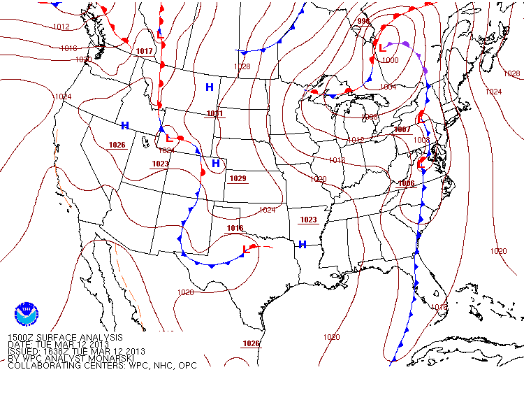
This was the surface analysis map taken earlier this Sunday morning. It shows that a warm front (located by the red semicircles along Georgia and the Atlantic Waters) has propagated northward (N) across Florida, and that has helped to drag up a considerable mass of maritime tropical (mT) air from the Caribbean waters. Any warm front that moves across the northern hemisphere will allow for the winds to veer (move counterclockwise) from the southeast to the southwest.  That wind flow helps to drag in moisture from the Gulf of Mexico, as well as the warmer air witnessed this weekend. At the same time, a cold front extending from the northern Mexican desert to the Florida Panhandle is bringing continental polar (cP) southward from its origins in Canada. This cold front is expected to clear south Florida and usher in colder and VERY dry air across the area (which I will discuss shortly after).

In the meantime, the combination of that warm air rising northward and that cold air sinking southward is helping to generate significant instability across most of the state, with rapidly moving severe thunderstorms across central Florida. These same severe thunderstorms forced the National Weather Service (NWS) forecast office in Melbourne, FL to issue a tornado warning for the Cape Canaveral, FL area earlier this afternoon (although no tornado formed), and the postponement of the final round of the Arnold Palmer Invitational Tournament at Bay Hill, FL until tomorrow morning. The squall line generated today was largely centered over central Florida, primarily north of Lake Okeechobee, before weakening as it headed further south. At this moment, the squall line is quickly weakening, although a light shower is still possible across the east coast metro areas. Also, a large portion of Florida was under a wind advisory today due to the pressure gradient formed by the low pressure system over Georgia. Winds in most areas were sustained at above 20 mph for a majority of the day, which can cause problems for drivers in SUVs or large trucks.

OUTLOOK

3-24-13 2

The current surface analysis shows that although the storms are ending across Florida, the cold front is lagging well behind, for it is still centered over the Tallahassee region. Nevertheless, it shall continue pushing southward through the overnight hours, and clear the Miami/Fort Lauderdale/Naples area by 11 AM tomorrow. At this time, given the current trends, morning lows across the area will be anywhere from 70-75 degrees. A later arrival of the cold front will allow for temperatures to rise through the morning, while a faster arrival will allow for temperatures to max out shortly after sunrise and steadily fall through the day. Therefore, the guidance consensus goes for the “middle man” estimate of a mid-morning frontal arrival.  Surely, winds are expected to start tomorrow out of the W and, once the front DOES move through,  winds will veer to out of the NW and begin to enforce the colder air and drying trend. It is possible that high temperatures may reach the low 80s in some areas prior to the frontal passage, but clearing skies will allow for good radiational cooling tomorrow night, and the drop in temperatures will certainly be felt as the night hours pass.

3-24-13 3

By Tuesday evening, the front will be well south of us and the cold, dry air mass will be in full command. Strong surface high pressure will set up over the Deep South, particularly between Louisiana to Missouri. This orientation of high pressure will drive NW to N winds across the state, leading to clear skies and excellent radiational cooling for Tuesday and Wednesday nights. There is a chance that some areas may experience record low temperatures for this time of year, since late March is not necessarily known for strong cold fronts as this one presents itself to be.

3-24-13 4

By the latter half of the work week, the high pressure system will build its way out towards the western Atlantic Waters. The surface pressures will begin lowering to seasonal levels, and a slow warming trend will be in store for the weekend as winds will veer to out of the NE and E by Friday afternoon. It is worth noting that although humidities will increase once again by the end of the week, drier air is expected to remain aloft, keeping thunderstorms out of the picture through next week.

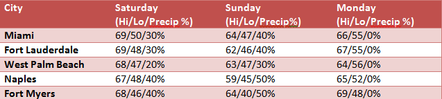
Temperature forecasts are located in the graph below. Keep in mind that these forecasts are for the airport locations only. If you are further inland, the temperature may be a few degrees cooler, and vice versa for coastal locations. Also, the forecasts for the latter part of the week are not expected to remain constant, so check my Twitter feed for updated forecasts each day (search @BrianWxFLA).

3-24-13 5

As you can see, the coldest temperatures are expected between Tuesday morning to Thursday afternoon. Perhaps on Wednesday, temperatures may struggle to reach 70 degrees across the general area. N winds will help to disperse the heating on the ground during the day, and calm winds overnight will allow for excellent radiational cooling, leading to the chilly morning temperatures. Get those jackets out just once more!


For more information and detail into the forecasts, you can view the forecast discussions that the NWS forecast offices put out every morning at these respective links:

NWS Miami: http://forecast.weather.gov/product.php?site=NWS&issuedby=MFL&product=AFD&format=CI&version=1&glossary=1

NWS Melbourne: http://forecast.weather.gov/product.php?site=NWS&issuedby=MLB&product=AFD&format=CI&version=1&glossary=1

NWS Tampa Bay/Ruskin: http://forecast.weather.gov/product.php?site=NWS&issuedby=TBW&product=AFD&format=CI&version=1&glossary=1


Weather outlook this week March 12-17

Good Tuesday to everyone! Well, it seems that we are returning to seasonably nice temperatures after a lengthy stretch of below average temperatures. However, as I’ll be discussing in this post, a change is once again in store.

RECAP OF COLD BLAST

To start the month of March, south Florida experienced well below average temperatures (at least 10 degrees below normal) for a stretch of almost 1 full week. Below are the graphs for temperatures with respect to average highs and lows, as well as dewpoint fluctuations:

Miami (KMIA): 1

Fort Lauderdale (KFLL): 1a

Palm Beach (KPBI): 1b

Naples (KAPF): 1c

Fort Myers (KFMY): 1d

*The red lines are the observed temperatures through the day, with the high temperatures as subsequent peaks and low temperatures as the lowest points. The green lines are the observed dewpoint fluctuations through the day. The blue lines indicate average high temperatures by the day on the top and average low temperatures by the day on the bottom.*

Throughout the first few days of March, temperatures were below average across the whole area as a series of cold fronts moved through in sequence. The strongest of those fronts passed through late on March 3rd, and sent temperatures to levels near freezing across well inland portions of S. FLA, not seen since the early 1940s and the 1993 Superstorm (which by the way, it is the 20th anniversary of this storm today). The peak of the cold air was set around March 4-5. Temperatures were about 10-15 degrees below normal values for this time of year, and it wasn’t till after March 9 that a rebounding trend started to take shape. Since then, the past couple of days have been seasonably mild.

SYNOPSIS

3-12-13 SA

Taking a look at the surface analysis from this morning, a low pressure system over the New England states and Quebec is propagating eastward, driving a trailing cold front to the east as well.  The tail end of this cold front is expected to pass south Florida later tonight and tomorrow morning. While there is plenty of rain and snow across the northeast, there is not much moisture associated with our end of this front due to the lack of moisture and instability ahead of it, so there is not much concern for thunderstorm development. However, a chance of showers cannot be ruled out as there will be an increase in moisture. This will be driven mostly by increasing southwest winds, which will push humid tropical air from the Caribbean and Gulf of Mexico. The best chance for rain can be found along the west coast areas such as Naples and Fort Myers.

OUTLOOK

3-12-13 Outlook A

Through this evening, the cold front will continue to push eastward across the area. Shower chances are expected to increase ahead of the front, but any rain will be light and very little to perhaps no measurable precipitation is expected. As the front continues to march, winds will veer to the southwest and west later this evening and overnight tonight. Temperatures are expected to remain mild, with western areas slightly cooler due to the enhanced onshore flow from the Gulf of Mexico.

3-12-13 Outlook 1

As the front clears the area tomorrow morning, shower chances will cease. Extensive cloudiness will begin to break apart to clear for sunshine by late morning and early afternoon. Highs tomorrow will be capped in the mid 70s for most of the area, and increasing northwesterly winds will help to usher the cooler air by nightfall.

3-12-13 Outlook 2

High pressure that is expected to move from the midwest to over Louisiana and Texas will build eastward as the front moves out of the area. Due to the expected sunny skies on Wednesday and Thursday, excellent radiational cooling will take effect and cool the overnight lows to the 40s and 50s across most parts, with possible 30s near the Lake Okeechobee region. Winds by the coastlines will be on the increase as well, with anticipated winds between 15-20 mph with gusts as high as 25 mph in some locations along the beaches. A slow but gradual warming trend will start Friday and carry through the weekend, with highs expected in the 70s and lows in the 50s and 60s. This will make for a very pleasant end of the work week and weekend. A steady north wind of 10-15 mph is anticipated, which will help to keep highs in check across most of S. FLA.

Also, it is worth mentioning that humidities behind this cold front will drop considerably, perhaps into the 20-30% across most areas. Accompanied with the consistent wind, this poses a high fire risk for the next few days. Therefore, be watchful for any fire weather watches/red flag warnings that may go in effect.

Weather outlook for week of March 4, 2013

Good afternoon everyone, and welcome to a fresh week. As you may have noticed, it was a very chilly start to the work-week. In fact, some areas in S. FLA reached low temperatures not seen for the month of March since the early 1940s and the Superstorm of 1993. Below are the unofficial lows recorded earlier this morning just after sunrise:

Untitled

The main contributor to the cold air this morning was due to the persistent north wind that was blowing through the overnight hours. This, along with clearing skies, allowed for temperatures to drop soon after sunset last night. Close to Lake Okeechobee, temperatures were at or near freezing for a few hours prior to sunrise, leading to the issuance of a freeze warning for Glades county. A freeze warning means that air temperatures in the warned area are expected to fall to near or below freezing (32 degrees) and may damage crops or harm animals that are left outdoors.

But, the skies are clear and there is excellent solar heating taking place across the area, allowing for temperatures to climb into the more comfortable 60s, despite the crisp breeze at the surface. This pattern is expected to continue for the rest of the day and keep beautiful, clear skies aloft. Later tonight, winds are expected to veer (rotate clockwise) to the northeast, allowing for a more moderate Atlantic breeze to push through the area, moderating temperatures. Let me mention, although the Atlantic breeze will help to keep temperatures up a bit compared to this morning, strong radiational cooling and the north breeze persisting through midnight will allow for temperatures to drop after sunset. Below are the expected lows for this evening into tomorrow morning:

Untitled 2


OUTLOOK FOR THIS WEEK:

usfntsfcwbg

The high pressure system that is over central Florida will build towards the east, making its way to the western Atlantic waters. This will allow for winds to veer to a more southeasterly flow and drive in some slight cloud coverage for Tuesday and Wednesday. Temperatures are expected to warm into the mid 70s along with increasing humidity back to seasonal levels. This will change as we head into the 2nd half of the work-week.


9jhwbg_conus

A mid-latitude cyclone that is forming over the midwestern states this week will move eastward towards the New England area and push towards the Atlantic waters. This low pressure is expected to deepen and drive a developing cold front towards the southeast. This front is expected to clear South Florida by Wednesday afternoon. It is worth mentioning that, because of the proximity and speed that this front will move at, it won’t be able to pick up much in the way of moisture. However, the modified arctic air over the plains will drag towards us and usher in a reinforcing shot of colder and drier air on Wednesday evening and for Thursday. Also, winds will pick up behind the front out of the north and northwest, so wind chills will dip once again to the 30s and 40s on Thursday morning. Below are the forecast low for Wednesday night and high for Thursday afternoon:

Untitled 3

High pressure should build back into the Atlantic by Friday, and we should expect the temperatures to slowly return to seasonal values by the end of the weekend.


SUMMARY:


After a cold start to March, we should expect a moderation in temperatures for Tuesday and Wednesday. Another front is expected to cross on Wednesday afternoon and usher in a reinforcing shot of these colder temperatures and drier air aloft, plus the extra wind component may drive wind chills back down to the 30s and 40s. A moderation trend is expected for the weekend and we should get back to seasonal values by next week. For those on Spring Break between March 11-15, it shall warm up just in time! But, I will update if this front is expected to come in stronger than currently predicted.


Cold air is on it’s way to S. FLA

Hello and a happy early Friday everyone! Here is an update to the cold air blast that we are expecting in South Florida, where we may possibly see the coldest temperatures since March 12-13 of 1993 during the “Storm Of The Century.”

SYNOPSIS

2-28-13 1

This is the most recent surface analysis map from NOAA’s HPC. Taking a look at it, we can see that the cold front that was mentioned earlier this week has cleared South Florida. However, it has now stalled over northern Cuba. This is allowing for north to northwesterly winds flow into the area and keeping the temperatures cool due to increasing low level cold air advection (CAA) . CAA is basically a term used when a cold front enters a region, and the warm air is forced upward into the atmosphere as the colder air mass wedges itself under, since cold air is denser than warm air.

There is a secondary cold front behind this stalled front, and this modified arctic front is slightly stronger than the first, and is expected to introduce the CAA starting tomorrow. High pressure situated across central Texas will build into the deep South and leave northwesterly winds as the dominating wind pattern over the next several days. This continuous NW wind will help to enhance CAA across all areas of S. FLA while simultaneously driving in moisture from the Gulf of Mexico. CAA should be underway across the area, but westerly winds and extensive cloudiness have held up the temperature drop so far. Most areas are still in the mid to upper 60s with overcast skies.

OUTLOOK THROUGH THIS WEEKEND:

2-28-13 3

Through Friday night and Saturday, CAA will continue to intensify across the area as the arctic airmass progresses to settle in. At this time, lows for Friday night are expected in the 40s across the metropolitan areas, except 30s near the Lake Okeechobee area and 50s along immediate coastal locations. Also, the wind chill factor will play a big role in how chilly it will feel. Most numerical model runs are inching towards wind chills below freezing near the Lake, and around the 40s across both coastal and metro areas. Daytime highs are expected in the 60s almost everywhere, but this will rely heavily on how much cloud coverage will be surrounding us. Higher cloud coverage means lower daytime heating content, thus cooler temperatures.

2-28-13 2

Taking a look at the model surface analysis extending through Sunday morning, another vigorous March cold front that is presently organizing itself over the northern U.S. will move southward across the area late Saturday evening into early Sunday morning. This new front will reinforce the CAA and usher in even colder air for Sunday afternoon through Monday morning. Also, persistent NW winds of 10-15 mph through the night may force wind chills below freezing over a greater area, so we may have to watch for a Wind Chill Advisory in the coming days. The uncertainty of the forecast at this point is high, but at this moment, highs are expected in the low to mid 60s with gradual clearing near sundown. CAA will peak through the night and radiational cooling may be in store, therefore we may see the coldest temperatures for March since WAY BACK WHEN during the 1993 Superstorm (video reference: Night 1: http://www.youtube.com/watch?v=5MpX2kFI0ok AND Night 2: http://www.youtube.com/watch?v=OsTswqsGd_o). Below is the list of current anticipated highs and lows:

2-28-13 4

Now, this is just the major cities. Obviously, if you are further inland than the large cities, temperatures will be slightly colder. Also, notice the precipitation chance for each city, and how it is elevated. What is expected to occur is that a shortwave trough is expected to develop and move across south Florida and, despite the colder air, the trough will make the atmosphere slightly more unstable than normal. So, there is the potential for a few showers to develop on Saturday night and Sunday. This will also play a role in how high temperatures will be during the day, and how cool it can get during the overnight periods.

SUMMARY

In short, the uncertainty of the forecast remains high, for it depends on A) when the cold front arrives; B) The amount of cloud cover that will surround S. FLA; C) The strength of the wind speed at the time of CAA; and D) For how long will there be rain falling, if any. Once again, the uncertainty of the forecast remains high, but it will be adjusted according to the new model runs and observations.

Weather outlook for this week February 25, 2013

Hello everyone. I know it has been roughly a month since my last post, due to coursework and other commitments.  I apologize for the delay. However, I am back and this next post includes a very interesting topic for us here in south Florida. Next week’s weather will be quite interesting and the pattern will possibly trickle into the following week.

As we approach the end of the winter season, we are in the midst of what is one of the warmest winters on record for a majority of the region. Steering currents have favored a persistent southeast wind flow which has helped to keep cold fronts at bay. Astronomically speaking, the winter season for the northern hemisphere ends on March 20th, and we usually get one last strong front around this time or slightly before it. That case seems to be increasingly likely, for a late season strong cold front is looming in the forecast.

SHORT TERM:

Before we take a look at the pending cold front, we will have to deal with increasing instability in the upper levels of the atmosphere. In other words, returning to what Florida knows best to make in the summer months: Thunderstorms.

MSL 1 ECMWF

MSL 1 GFS

This is the Mean Sea Level (MSL) model map, which shows the average pressure of the surrounding airmasses. This model is also a good indication of precipitation and detecting low and mid-latitude cyclones (seen in the green/mustard yellow blob east of the Carolinas). The top image is the MSL from the European Centre for Medium-range Weather Forecasts (ECMWF) model, while the bottom image is the MSL from the Global Forecasting System (GFS) model, both taken at 72 and 66 hours from the most recent run, respectively. Both models indicate a shortwave trough moving across the east coast and is expected to stall just to the southeast of us. This should create enough instability to generate showers and thunderstorms. Increasing chances for rain are expected to start Tuesday morning, with the best chance for any activity coming on Wednesday evening/Thursday morning.


LONG TERM:


This is where the weather patterns will become real interesting and bears close monitoring. All signs point to a late season cold front pushing through the area. However, both of the models differ significantly in the evolution and movement of the mid-latitude cyclone set to form over the Midwest states.

GFS 2-24 1

GFS 2-24 2

GFS 2-24 3

GFS 2-24 4


This is the GFS model measured at the 850 mb level (about 5,000 feet above the surface). These images span from 117 hours to 192 hours from the most recent full run. The GFS is leaning to a more aggressive frontal system that will send colder air deep to the south, with near freezing (aqua colored or darker) approaching much of the area. This translates into potential 30s and 40s for inland areas, and low 50s along immediate coastal areas. With the GFS, it is expected to last for more than 3 days, possibly more than 5 days at the current predictions.


ECMWF 2-24 1

ECMWF 2-24 2


This is the ECMWF prediction of the 850 mb temperatures. Due to the lack of data that was available, the two images span a time frame of 114-135 hours from the most recent full run. What separates this from the GFS is how deep the trough extends into S. FLA. With this model run, the ECMWF keeps the coldest of the air just to the north of S. FLA, sending cool, but nowhere near as much cool air as the GFS predicts. To translate this map, most inland areas would level out in the 40s, with mid-upper 50s across most of the coastal areas.


There is a similarity between both models. If you notice the arrows on the map, those are wind vectors that estimate potential wind speeds at the 850 mb level. Winds may increase noticeably out of the northwest as the front passes, and this is the tell-tale sign of how long the cool airmass will last.


SUMMARY:


In short, the information that is known so far is limited, but what can be said is a shot of cooler and drier air is increasingly likely to start off March. The last significant March cold front dates back all the way to the 1993 Superstorm of March 12-14. Going with the ECMWF would indicate more moderate temperatures; going with the GFS would spell sharply cooler air and potential record low temperatures in isolated areas for given days in March.


I will be posting a blog later this week with an update to the situation.


Onward and upward,


Brian Matilla